03.10 Lappjordhytta - Pålnostugan
2.7km
Distance
-
Walking time
76m
Total climb
242m
Total descent
Photos
Stage description
N.B.: We don't have an English description of the stage just yet. We'll give you the German version for now until the English version is ready.
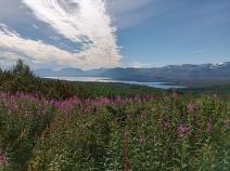
Von der Lappjordhytta ist es nur noch einen Kilometer bis zur schwedischen Grenze, wobei es kräftig bergab geht. Der markante Grenzstein befindet sich auf einer kleinen Anhöhe in einer Niederung. Auf schwedischer Seite geht es im ständigen Bergauf-Bergab durch dichten Wald zur Pålnostugan, direkt am Torneträsk. Die Hütte kann kostenlos genutzt werden, ist jedoch nur sehr spartanisch eingerichtet. Im Sommer 2022 war hier jede Menge Baumaterial gelagert. Möglicherweise ist in naher Zukunft eine Renovierung angedacht.
The following users contributed to this text:
Hiking maps
No maps added yet
Marking
-
 Hiking trail (Sweden)
Accommodation
| Accommodation | Price group | |||
|---|---|---|---|---|
| 0-200 NOK |
201-400 NOK |
401-600 NOK |
>601 NOK |
|
|
Lappjordhytta
Price group:
|
||||
| 0-200 SEK |
201-400 SEK |
401-600 SEK |
>600 SEK |
|
|
Pålnostugan
Price group:
|
||||
Links
DNT - Stage descriptions (PDF)
Detailed information by the DNT about the E1 from North Cape (NO) to Grövelsjön (SE). Including stage descriptions, accomodation, marks and maps. In norwegian language.
Literature
Sources and copyright
Information about accommodation, maps and marking of this stage is based on information by DNT (Den Norske Turistforening) - Published under CC BY-SA 4.0 License GPX track coordinates: © OpenStreetMap contributors. Published under Open Database License (ODbL)GPX-Downloads
You can use the GPX track for navigation and tour planning on your digital device (GPS, smartphone, online tour planner).
| Etappe Stage 03.10 Lappjordhytta - Pålnostugan | Download (.gpx) |
| All tracks in Norway, Finland and Sweden | Download (.zip) |
The download and many of the services offered on this page are free of charge. However, I would greatly appreciate a small donation as a token of appreciation for my work! This can be done through Paypal or a supporting membership. Thank you very much!