11.02 Stensjön - Äskhult
14.9km
Distance
-
Walking time
538m
Total climb
457m
Total descent
Photos
Stage description
N.B.: We don't have an English description of the stage just yet. We'll give you the German version for now until the English version is ready.
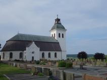
In Fjäras gibt es einen Tempo-Supermarkt, der recht gut bestückt ist. Gegenüber ein Bäcker, der einige Leckereien bereit hält. Wer mag, besucht die Kirche. Kurz hinter dem Ort gibt es ein Museum mit angegliederter Restauration und Self-Service.
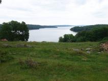
Direkt am See Lygnern kann man an der Badestelle übernachten. Wasser gibt's am Museum, Toilette ist am Parkplatz vorhanden.
Auf breiten Wegen geht es nach Äskhult. Dort gibt es eine Schutzhütte in der man gut übernachten kann und ein Toilettenhäuschen. Etwas höher gelegen findet sich ein Hofmuseum mit Café. Es gibt Sandwich, Kaffee und Kuchen.
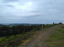
Der Hallandsleden bleibt, wie bereits gewohnt: breite Wirtschaftswege wechseln sich mit schmalen Waldpfaden ab. Es geht rauf und runter.
Eine lange Zeit geht es unter Überlandleitungen entlang, das ist nicht so schön.
Hiking maps
No maps added yet
Marking
-
 Hiking trail (Sweden)
Accommodation
| Accommodation | Price group | |||
|---|---|---|---|---|
| 0-200 SEK |
201-400 SEK |
401-600 SEK |
>600 SEK |
|
|
Vindskydd Äskhult
Äskhut
Price group:
|
||||
Links
Sources and copyright
GPX track coordinates: © OpenStreetMap contributors. Published under Open Database License (ODbL)GPX-Downloads
You can use the GPX track for navigation and tour planning on your digital device (GPS, smartphone, online tour planner).
| Etappe Stage 11.02 Stensjön - Äskhult | Download (.gpx) |
| All tracks in Norway, Finland and Sweden | Download (.zip) |
The download and many of the services offered on this page are free of charge. However, I would greatly appreciate a small donation as a token of appreciation for my work! This can be done through Paypal or a supporting membership. Thank you very much!